A measured building survey captures the internal layout, dimensions, and key features of a building. It's the accurate foundation that architects, designers, and property professionals need when working with existing buildings.
This guide explains what measured building surveys include, when they're necessary, and what to expect from the process.
What Does a Measured Building Survey Capture?
A measured building survey records the physical reality of a building — not what the original drawings showed, but what actually exists today. Buildings change over time, and original drawings (if they exist at all) often don't reflect alterations, extensions, or simple construction variations.
A comprehensive survey typically includes:
Floor plans
Accurate plans of each floor showing:
- Room layouts and configurations
- Wall positions and thicknesses
- Door and window positions
- Stairs, lifts, and circulation routes
- Built-in features (fireplaces, cupboards, service risers)
- Floor level changes (steps, ramps, split levels)
Dimensions
All key measurements:
- Room sizes
- Wall lengths
- Opening widths
- Ceiling heights
- Floor-to-floor heights
Dimensions are typically shown to the nearest 10mm — more than sufficient for most design purposes.
Elevations
External façades showing:
- Window and door positions
- Roof lines (ridges, eaves, verges)
- Ground levels
- Key heights
- Architectural features
Elevations are essential for planning applications, heritage work, and any design affecting the building's external appearance.
Sections
Vertical cuts through the building showing:
- Floor-to-floor heights
- Ceiling heights
- Roof construction (where visible)
- Level changes
- Relationship between floors
Sections help designers understand the three-dimensional reality of a building — something floor plans alone can't fully convey.
Roof plans
For complex buildings:
- Roof shapes and pitches
- Valleys, hips, and ridges
- Roof lights and dormers
- Drainage (gutters, downpipes)
When Do You Need One?
Measured building surveys are typically required for:
Refurbishment and renovation
Before designing alterations to an existing building, you need to know what you're working with. Architects can't design an extension, reconfigure a layout, or specify new elements without accurate existing information.
Planning applications
Planning applications for work to existing buildings need accurate drawings showing:
- Existing layouts and elevations (what's there now)
- Proposed layouts and elevations (what you want to do)
The local authority assesses the proposal against the existing situation. Inaccurate existing drawings undermine the entire application.
Lease plans
New leases require plans showing the demised premises — the space being let. For simple situations, this might be straightforward. For parts of buildings, particularly commercial premises, accurate floor plans are essential.
Lease plans need to clearly show:
- The extent of the demised area
- Access routes and common parts
- Any areas excluded from the lease
Getting lease plans wrong causes problems for years — disputes about what's included, confusion about maintenance responsibilities, difficulties on assignment or renewal.
Heritage and listed buildings
Work to listed buildings requires detailed understanding of what exists. Historic England and local conservation officers need accurate drawings to assess proposals.
Heritage work often requires more detail than standard surveys — recording architectural features, historic fabric, and evidence of previous alterations.
Property transactions
Buyers sometimes commission measured surveys when:
- The property is complex or unusual
- Existing drawings are unavailable or unreliable
- They're planning immediate works after purchase
- Area verification is important (commercial property, in particular)
Knowing exactly what you're buying — room sizes, ceiling heights, configuration — matters for pricing, planning, and future use.
Facilities management
Organisations managing building portfolios need accurate records:
- Space planning and allocation
- Maintenance planning
- Health and safety compliance
- Asset management
Out-of-date or inaccurate drawings cause ongoing problems. A proper survey provides a reliable baseline.
What About Existing Drawings?
Original architectural drawings often exist, but they may not be reliable:
- As-built variations — What was constructed doesn't always match what was drawn
- Subsequent alterations — Extensions, internal changes, removed walls
- Simple age — Old drawings may be scaled inconsistently or damaged
- Missing information — Original drawings may not show everything you need
Review Service
Accuracy and Level of Detail
Measured building surveys aren't about millimetre precision in laboratory conditions. They're about capturing reality accurately enough for practical purposes.
For most design work, dimensions to the nearest 10mm are appropriate. Walls that are nominally straight probably aren't perfectly straight — and showing them as perfectly straight in the drawing is the right approach for design purposes.
Where higher precision is required — historic buildings, specialist fit-outs, coordination with structural work — we can survey to tighter tolerances.
The key is matching the survey specification to the purpose. Over-specifying wastes money; under-specifying causes problems. We can advise on the appropriate level for your project.
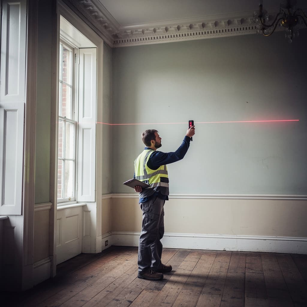
Survey Methods
We use a combination of techniques depending on the building:
Laser distance measurement
Handheld laser devices for measuring rooms, openings, and features. Quick, accurate, and suitable for most internal measurement work.
Total stations
Precision instruments for establishing accurate control networks, measuring complex spaces, and tying internal surveys to external positions.
Laser scanning
For complex or highly detailed requirements, 3D laser scanning captures millions of points, creating a detailed “point cloud” of the building. This can then be used to produce drawings, 3D models, or specialist outputs.
Scanning is more expensive than traditional measurement but captures more detail and can be more efficient for large or complex buildings.
The right method depends on the building, the purpose, and the budget. We'll recommend the appropriate approach for your situation.
The Survey Process
Brief and quotation
We need to understand:
- The building: location, size, type, complexity
- The purpose: what decisions will the survey inform?
- The deliverables: floor plans, elevations, sections, 3D models?
- The format: DWG, PDF, other requirements?
- Access arrangements: who to contact, any restrictions?
Based on this, we can quote and confirm the scope.
Site survey
We'll need access to all areas being surveyed. For occupied buildings, some coordination may be required. For commercial premises, surveys can often be conducted outside working hours if that's more convenient.
Processing and drawing
Drawings are produced in CAD (computer-aided design) software, allowing accurate scaling, layering, and future editing.
Delivery
Finished surveys are delivered in your preferred format:
- DWG — For use in AutoCAD and most design software
- DXF — Universal CAD exchange format
- PDF — For viewing, printing, and sharing
- 3D models — For BIM workflows or visualisation (where specified)
We can also provide printed copies at specific scales if required.
Deliverable Formats
Different purposes require different outputs:
| Purpose | Typical Format |
|---|---|
| Architectural design | DWG files, layered for editing |
| Planning applications | PDF plans and elevations at specified scales |
| Lease plans | PDF with clear demise markings, suitable for Land Registry |
| Heritage recording | Detailed PDF drawings, sometimes with 3D models |
| Facilities management | DWG or PDF, sometimes linked to asset management systems |
We can discuss specific requirements and advise on the most appropriate format.
Common Questions
How long does a survey take?
Site work: a few hours for a small property, a few days for a large or complex building. Processing: typically one to two weeks, depending on complexity. Urgent turnarounds can sometimes be accommodated.
Do I need to clear the building?
Not usually. We work around furniture and occupants. For the most accurate results, access to walls, corners, and openings is helpful — but we're used to surveying occupied buildings.
What if I can't access some areas?
We'll survey what we can access and note areas that couldn't be measured. Sometimes we can estimate dimensions from external measurement or existing information. We'll be clear about what's measured and what's estimated.
Can you survey a building I don't own?
We need permission from whoever controls access. If you're a prospective buyer or tenant, the current owner or agent typically grants access for survey purposes.
Do you need the original drawings?
They're useful for context but not essential. We measure what exists, not what drawings show. If you have original drawings, we're happy to review them — but we don't rely on them.
Costs
Measured building survey costs depend on:
- Building size — More floor area takes longer
- Complexity — Simple layouts vs. complex configurations
- Level of detail — Standard survey vs. high-precision or heritage-level recording
- Deliverables — Floor plans only vs. full plans, elevations, and sections
- Access — Single visit vs. multiple visits required
For a typical residential property, expect costs in the range of £600–1,500 plus VAT. Commercial buildings and larger properties vary more widely depending on size and complexity.
We're happy to provide a quotation based on your specific requirements.
Whether you're planning alterations, preparing lease documentation, or simply need reliable records, a proper survey provides the foundation for everything that follows.