Boundary disputes are among the most common causes of neighbour conflict in the UK. They can also be among the most stressful — and expensive — if not handled sensibly.
This guide explains how boundaries actually work in English and Welsh law, why disputes arise, and how professional surveying can help establish the facts before matters escalate.
What is a Boundary Dispute?
A boundary dispute occurs when two or more landowners disagree about the position of the line separating their properties. This might sound straightforward, but boundaries are rarely as simple as people assume.
Disputes typically arise from:
- Unclear or missing boundary markers — The original fence, wall, or hedge has gone, and nobody is quite sure where it stood.
- Discrepancies between physical features and title plans — What's on the ground doesn't match what's on the plan. This is surprisingly common.
- Historical changes — Land use, occupation, or physical features have changed over decades. A hedge planted in the 1950s may not be where the legal boundary lies.
- New construction — Extensions, outbuildings, or new fences built near a boundary can trigger disputes about the exact line.
- Overgrown vegetation — Original boundary features become obscured, and assumptions are made about where the line runs.
The General Boundaries Rule
Here's something that surprises many property owners: the Land Registry does not guarantee exact boundary positions.
When you look at a Land Registry title plan, you'll see a red line around the property. Most people assume this line shows precisely where their boundary lies. It doesn't.
Land Registry plans operate under the “general boundaries rule.” The red edging indicates the approximate position of the boundary — not the exact line. The Land Registry's own guidance is clear on this point: the title plan shows the general boundary only.
The actual legal boundary may differ from the red line, particularly where:
- Physical features have moved or been replaced over time
- The original Ordnance Survey mapping was imprecise
- Features like thick hedges make the exact line unclear
Why This Matters
Where Does the Legal Boundary Actually Lie?
If the title plan doesn't show the exact boundary, what does?
The legal boundary is determined by the conveyance or transfer that created it — typically the deed from when the land was first divided. This might be a document from 50, 100, or even 200 years ago.
These original documents often contain a plan and a verbal description of the boundary. Sometimes they're precise. Often they're not. Phrases like “along the hedge” or “following the fence” were common, and the physical features they refer to may have changed significantly since.
Establishing the legal boundary therefore requires:
- Finding the original conveyancing documents — Not always easy, particularly for older properties.
- Interpreting what they meant at the time — Legal and surveying conventions have changed.
- Comparing with what exists on the ground today — Measured accurately, not estimated.
This is where professional surveying becomes useful.
How Professional Surveying Helps
A boundary survey provides objective, measured evidence. It doesn't determine who's “right” — that's a legal question — but it establishes the facts clearly so that informed decisions can be made.
A professional survey typically provides:
- Precise measurement of existing physical features — Where fences, walls, hedges, and other boundary features actually stand, measured to centimetre accuracy using GPS and total station equipment.
- Comparison with documentary evidence — Overlaying the measured positions onto title plans, historical Ordnance Survey maps, and original conveyance plans.
- Identification of discrepancies — Clear mapping of where documents and physical features disagree, and by how much.
- Analysis of historical changes — Using archived mapping to understand how the boundary has evolved over time.
The result is a factual record that both parties — and their solicitors — can rely on.
The Survey Process
A typical boundary survey involves four stages:
Desktop Research
Before visiting the site, we examine:
- Land Registry title plans and registers for both properties
- Any available original conveyance or transfer documents
- Historical Ordnance Survey mapping (often going back to the 1880s)
- Aerial photography where relevant
This research often reveals useful context — for example, that a hedge was planted after the boundary was established, or that a fence has been replaced in a different position.
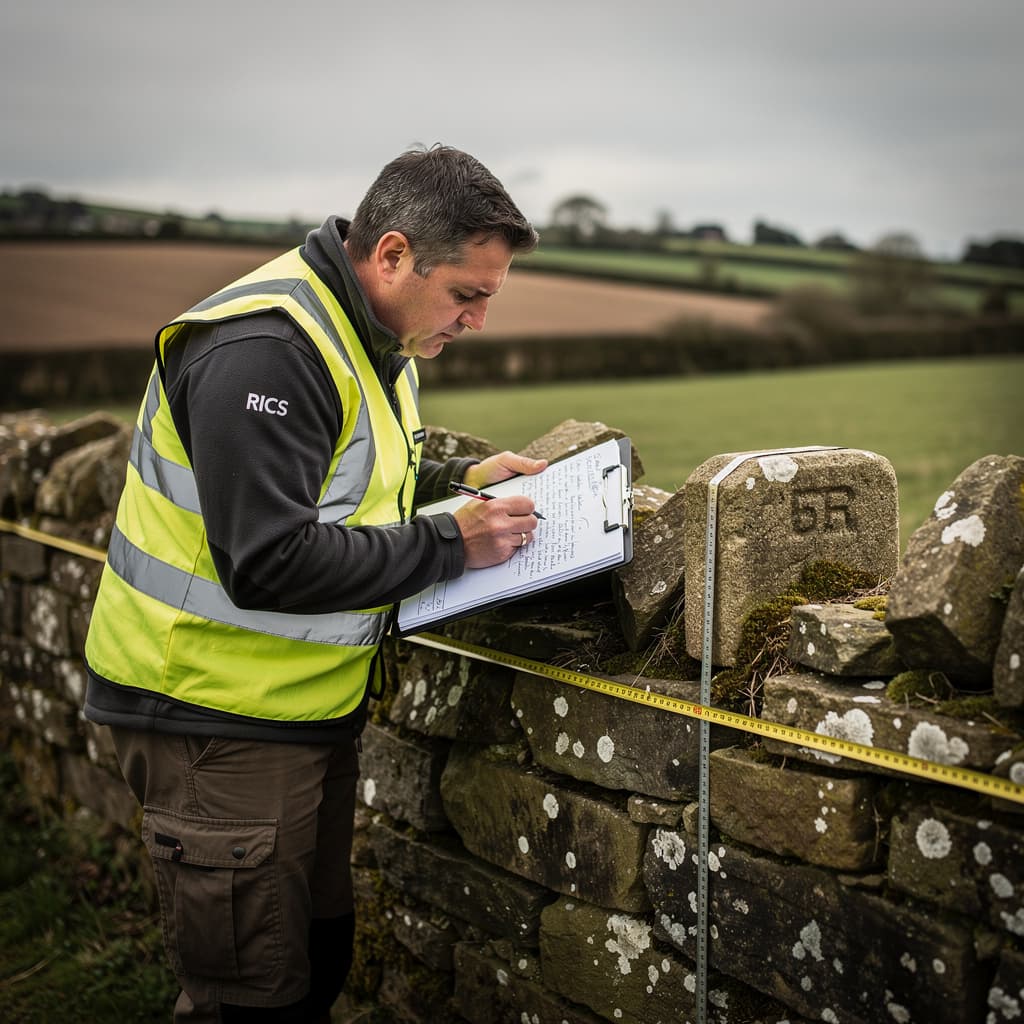
Site Survey
We visit the site to measure the position of all relevant boundary features using GPS and total station equipment. This typically includes:
- Fences, walls, hedges, and any boundary markers
- Buildings near the boundary
- Any features referenced in title documents
Measurements are tied to the Ordnance Survey National Grid, allowing direct comparison with OS mapping and title plans.
Analysis
The measured survey is overlaid onto the documentary evidence. This reveals:
- Where the physical boundary matches the documents
- Where discrepancies exist, and their extent
- How the situation has changed over time
We also consider relevant legal principles — for example, hedge and ditch presumptions, or the significance of long occupation.
Reporting
The findings are presented in a clear written report with supporting plans. This typically includes:
- A summary of the documentary evidence
- A plan showing measured positions overlaid on title plans
- Commentary on discrepancies and their possible causes
- Options for resolution, where appropriate
The report is designed to be useful to solicitors, mediators, or — if necessary — the court.
When to Seek Professional Help
Not every boundary query requires a surveyor. Sometimes a straightforward conversation with your neighbour resolves the matter. Sometimes a solicitor can clarify the position from the documents alone.
But professional surveying is worth considering when:
- You're buying or selling property and the boundary position is unclear or disputed. Better to establish the facts before exchange than after.
- A neighbour disputes your understanding of the boundary and informal discussion hasn't resolved things. An objective survey gives both parties the same factual basis.
- You're planning construction near a boundary — an extension, outbuilding, or new fence. Knowing exactly where the boundary lies avoids expensive mistakes.
- You need evidence for legal proceedings. Surveyors can provide factual evidence; solicitors and barristers handle the legal arguments.
- You want to apply for a determined boundary at the Land Registry, replacing the general boundary with a legally fixed line.
A Word on Costs and Proportionality
Boundary disputes can become expensive — sometimes wildly disproportionate to what's actually at stake. We've seen cases where legal costs exceed the value of the disputed land many times over.
A professional survey costs a fraction of what contested legal proceedings cost. More importantly, it often provides the clarity needed to resolve matters without going further.
Sometimes the survey confirms what you hoped. Sometimes it doesn't. Either way, knowing the facts early allows sensible decisions about whether — and how — to proceed.
What About Expert Witness Work?
For disputes that proceed to court or tribunal, surveyors can provide expert witness services — formal reports and testimony meeting the requirements of the Civil Procedure Rules.
Patrick Rose, our managing director, has over 30 years of experience in boundary matters and has previously been appointed jointly or directly by the court to assist in boundary determinations.
However, we'd make a broader point: most disputes shouldn't reach court. The costs are high, the outcomes uncertain, and the process stressful for everyone involved. A good survey early in the process often provides the basis for negotiated resolution — which is usually the better outcome for all parties.
The Determined Boundary Procedure
If you want certainty — a legally fixed boundary line rather than a general boundary — you can apply to the Land Registry for a “determined boundary.”
This requires:
- An exact plan meeting Land Registry specifications
- Evidence supporting the boundary position
- Agreement from the adjoining owner, or a formal objection process
We can prepare the necessary survey and plans for a determined boundary application. It's not always necessary, but for some situations — particularly where a boundary has been disputed — it provides permanent clarity.
Summary
Professional surveying helps by establishing the facts: where things actually are, what the documents say, and where they disagree. This evidence supports sensible decision-making, whether that leads to negotiation, formal resolution, or simply accepting that the boundary is where you thought it was.